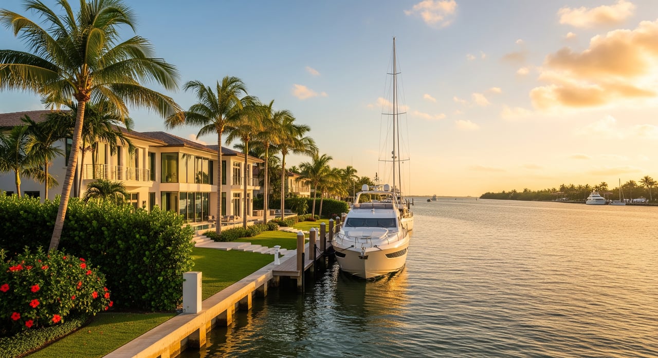
Shopping waterfront in Fort Lauderdale and keep seeing “no fixed bridges” in the listing details? If you own a sailboat or a sport yacht, that phrase can make or break a property’s value for you. Still, it is often used loosely, and the fine print matters. In this guide, you’ll learn exactly what it means in Broward, how local routes work, which measurements matter, and how to verify a property’s true ocean access before you buy. Let’s dive in.
What “no fixed bridges” means
In South Florida listings, “no fixed bridges” typically means you can travel from the property’s dock to the Intracoastal Waterway or the Atlantic Ocean without passing under a permanent, non‑opening bridge that limits height. For tall vessels, that is a big deal. It signals you should be able to clear every crossing on your route without lowering masts or radar arches.
Treat it as a starting point, not a guarantee. The phrase does not define the specific route, tidal assumptions, or water depths. You should confirm the exact path the seller uses and how it applies to your boat.
Fixed vs movable bridges
- Fixed bridge: A permanent span with a set vertical clearance. If your boat’s highest point is taller than that clearance at the current tide, you cannot pass.
- Movable bridge: A drawbridge or similar span that opens on schedule or on demand. These are common on the Intracoastal and many canals in Broward. Their operation is governed by U.S. Coast Guard drawbridge operation rules.
Movable bridges solve height limits but can add timing considerations.
Air draft explained
Your boat’s “air draft” is the distance from the waterline to the highest fixed point. Think masthead, hardtop, antennas, and dinghy on davits. Measure it at your loaded waterline. That number is your minimum required clearance beneath any span, and it is the key to deciding if a property truly works for your vessel.
Fort Lauderdale waterways overview
Fort Lauderdale is called the “Venice of America” for good reason. A dense network of residential canals connects to the Atlantic Intracoastal Waterway (AIWW), which runs along the barrier islands and links to Port Everglades Inlet for ocean access. The Fort Lauderdale–Pompano Beach–Deerfield Beach area offers multiple ways to reach the ocean, but your actual route depends on the property’s canal, your vessel size, and bridge operations.
Routes to the ocean
Most owners track from a neighborhood canal to the Intracoastal, then south or north to Port Everglades Inlet. Some inland shortcuts may include small fixed spans. By contrast, the primary ICW route often relies on drawbridges that open for marine traffic. The right path for you balances bridge openings, turning basins, and water depth.
Key measurements to know
Two numbers drive your decision: your air draft and the vertical clearance of each bridge on your route. Compare them using official sources, and pay attention to the tidal reference used for each bridge’s posted clearance.
Tides and vertical datum
Bridge clearances are published relative to a tidal datum such as Mean High Water. Tide height changes actual clearance. Fort Lauderdale’s typical tidal range is modest, often on the order of a couple of feet, but that can be decisive for a tall rig. Check local predictions through NOAA tide predictions and confirm the datum on any bridge clearance you rely on.
Depth and turning room
Vertical clearance is only half the story. Controlling depth is the shallowest point on your route, and it governs your vessel’s draft and safe passage. Federal channels like the Port Everglades entrance are maintained by the U.S. Army Corps of Engineers Jacksonville District, but residential canals and lateral channels can shoal. You also need adequate beam and turning room in the canal or basin near your dock.
Review official charts and talk with local marinas about recent dredging, shoaling, and practical turning radii for your size class.
Bridge operations and timing
Drawbridges are a fact of life in Broward. Many open on demand outside rush hours, while others follow set intervals or restrict openings during peak traffic. Weather, special events, and maintenance can affect schedules. Before you commit to a property, review the applicable spans and their operating rules in the Coast Guard regulations and confirm current notices with local authorities.
Hurricane planning and insurance
In storm conditions, movable bridges that normally open may be secured for safety. Even with “no fixed bridges,” poor weather or channel conditions can limit egress. Lenders and insurers may also weigh flood elevation, surge exposure, and mitigation features alongside navigational access. The takeaway: consider storm planning, not just daily cruising, when evaluating your dock and route.
How to verify for a specific property
A disciplined check saves time and risk. Use this step‑by‑step process before you rely on the phrase “no fixed bridges.”
Step 1: Ask for the exact route
Request the seller’s or listing agent’s precise path to the Intracoastal and to Port Everglades. Get bridge names, mile markers, and whether the claim refers to ocean access or only to the ICW.
Step 2: Check official charts
Confirm every span and channel along that route using NOAA nautical charts. Verify bridge types, vertical clearances, aids to navigation, and charted depths. For ocean access, review Port Everglades approach channels and turning basins.
Step 3: Confirm tidal reference
Ask which datum each clearance uses, such as Mean High Water. Compare to your measured air draft at the loaded waterline, then check timing against NOAA tide predictions for typical transit windows.
Step 4: Verify controlling depth
Speak with nearby marinas and boatyards about recent soundings, shoaling, and dredging. Ensure there is enough depth at your dock and along the canal, plus adequate turning room for your beam and length.
Step 5: Get on‑the‑water confirmation
If possible, run the route with your vessel or a similar boat at representative tides. Consider hiring a local captain or marine surveyor to validate air draft clearances, depths, and maneuvering constraints.
Step 6: Review bridge operations
Pull operating schedules and any restrictions from the U.S. Coast Guard rules. Check for maintenance or event closures with local municipalities or the Port Everglades Authority.
Why routes matter in Broward
Two homes a mile apart can have very different realities on the water. One canal may lead directly to the ICW with only drawbridges, while another requires passing under a low fixed span before you reach a movable bridge. Some owners accept scheduled openings for a larger boat. Others prefer a route with no vertical limitations at any tide state. Your boating style and vessel profile should drive your selection.
Practical day‑to‑day considerations
- Peak timing: Expect delays during rush hours when certain bridges limit openings, and plan departures to avoid queues near the inlet on busy weekends.
- Port traffic: Cruise ships and commercial traffic can influence movement around Port Everglades. Check notices and be patient with safety zones.
- Noise and wake: Popular channels can be lively. Evaluate wake exposure and seawall condition at the dock, especially for longer yachts.
Chart and notice resources
Authoritative sources keep you grounded:
- NOAA nautical charts for bridges, depths, and aids
- NOAA tide predictions for timing clearances
- U.S. Coast Guard drawbridge rules for schedules and restrictions
- U.S. Army Corps of Engineers Jacksonville District for federal channel depths and maintenance
- Port Everglades Authority for local port notices
Buyer checklist
Use this quick list when a property claims “no fixed bridges.”
- Measure your air draft at the loaded waterline, including antennas and dinghy.
- Get the seller’s exact route to the Intracoastal and ocean.
- Identify each bridge by name and type along the route.
- Confirm bridge clearances and datums on NOAA charts.
- Check tide windows for your typical departure times.
- Verify controlling depth in the canal and at the dock.
- Assess turning basins and approach width for your beam and length.
- Review drawbridge schedules and any peak‑period restrictions.
- Consider hurricane egress realities and insurer requirements.
- Do a field transit or hire a local captain or surveyor.
Work with a trusted advisor
For many buyers, “no fixed bridges” is more than a line in a listing. It is a lifestyle and operational requirement tied to a significant asset on the water. You deserve precise guidance on routes, tides, depths, and value impact before you commit.
If you are evaluating Fort Lauderdale or broader Broward waterfront, request a confidential consultation. We can align your vessel profile with viable neighborhoods, coordinate with marina managers and surveyors, and structure a deal that reflects real on‑the‑water access. When you are ready, schedule a private consultation with Isaac Malagon - Sotheby’s.
FAQs
What does “no fixed bridges” mean in Fort Lauderdale listings?
- It indicates a route from the property to the Intracoastal or ocean without passing under any permanent low bridges, but you must confirm the exact route, bridge clearances, tides, and depths.
How do I know if my yacht can clear local bridges?
- Measure your air draft from the waterline to your highest fixed point, then compare it to official bridge clearances on NOAA nautical charts and account for the tide using NOAA tide predictions.
Do movable bridges cause delays in Broward County?
- Yes, some drawbridges operate on schedules or restrict openings during rush hours; review the U.S. Coast Guard rules and plan departures to minimize wait times.
Does depth or tide limit ocean access in residential canals?
- Often, yes; controlling depth in canals or basins can limit draft, and even a couple of feet of tide can determine whether you clear a span or avoid a shoal.
What is the best way to verify a property’s ocean route?
- Ask for the seller’s route, confirm it on NOAA charts, check tides and bridge rules, and perform a test transit or hire a local captain or marine surveyor for on‑the‑water verification.